Saturday 10 October 2015

considered interpretation of the sediments

Curiosity rover: The reward for 'whale watching' on Mars

     
  • From the sectionScience & Environment
Whale RockImage copyrightNASA/JPL-CALTECH/MSSS
Image captionWhale Rock is about 50cm high and is made from sediment grains that bounced along a rippling stream bed
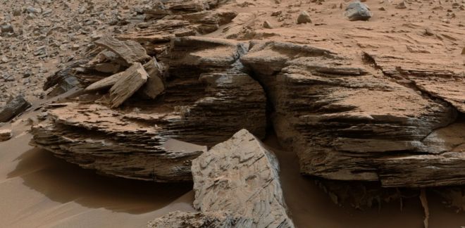
Whale Rock. It's got quite a story to tell.
When scientists first saw it in images returned from Nasa's Curiosity rover on Mars, they really weren't sure what to make of it.
Sitting proud on top of a stack of finely layered mudstones, this coarser sandstone outcrop seemed a little out of place.
So, the team commanded the robot to drive up and down for a bit, to look at some other enticing geology in Gale Crater.
But each time Curiosity came back for another peek, the head-scratching continued.
What was Whale Rock, and why was it there?
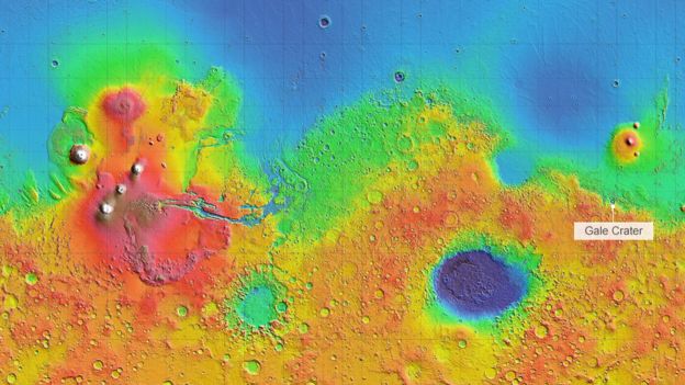
This week the team released its considered interpretation of the sediments observed in Gale during more than a year's roving by Curiosity.
The report, published in Science magazine, describes how these sediments are likely the remains of streams and rivers that flowed over the crater's rim and across its floor, slowing and branching into deltas that ultimately fed a succession of persistent lakes.
And Whale Rock, it turns out, has something of a starring role in this story.
"It's the rock that gives us confidence that we've got our model right," says Sanjeev Gupta, a senior scientist on the mission.
Much of what is in the Science paper was first discussed last December in a mission-team teleconference with reporters.
The intervening months have witnessed the hard graft needed to corral all the evidence into the kind of arguments that will pass muster in a peer-reviewed scholarly journal. And those arguments are compelling.
The KimberleyImage copyrightNASA/JPL-CALTECH/MSSS
Image captionThe dipping rock strata in Gale align with the direction of water flow - towards the mountain
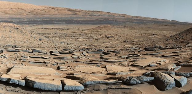
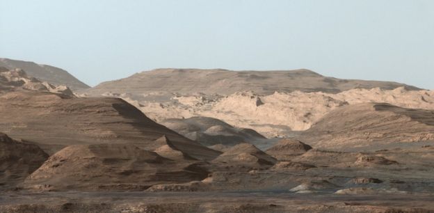
The coarser gravels that the robot saw out on the crater floor, near its landing point, gave way to progressively smaller-grained rocks as it drove south, closer to Gale's dominating central mountain, Aeolus Mons (Mount Sharp). And these dipping strata ended in a thick collection of finely layered mudstones.
The laminations are what you would expect when plume after plume of sediment pulses into a lake, loses energy and settles out of the standing water to build up the bed.
And Whale? It sits above 10m or so of these exquisite mudstones, somewhat nestled in them, and lens-shaped.
Whale has laminations, too, but its larger grains are those of a sandstone, meaning its deposition environment was more energetic. Its sediments were carried in rippling water.
All that head-scratching has concluded that Whale marks the physical edge of a lake - the interface with the delta that was feeding it.
There are two ways it could have formed.
Media captionSanjeev Gupta: "Our analysis follows many months of detailed debate and argument"
One interpretation is quite straightforward: it is the delta deposits actually encroaching into the lake, filling little gullies.
The second possibility is a bit more involved: it could be where the lake has receded at some point, and the feeding stream from the delta has cut down and eroded a new channel. The stream's own sediments have then rolled into this channel but have later been encased by the finer muds when the lake level has come back up.
Either way, you are looking at a rock recording of events that occurred, perhaps over just a few hours and days, more than three billion years ago on another planet.
Odyssey's Mola map of elevation on MarsImage copyrightNASA/MOLA
Image captionGale Crater sits on the "dichotomy" - the divide between the northern lowlands and the southern highlands
"So, one explanation for Whale is a static model, and the other is a dynamic time model," explains Prof Gupta, from Imperial College London.
"The latter may be right, and that would be really exciting because it is telling us something about the water budget changing. But the important thing is that we are seeing the interface between the rivers and the lakes.
"Whale is a marker for us that they existed at the same time, and that really gives us confidence in particular that we are seeing ancient lake deposits."
Curiosity's big drive to Mount Sharp saw it climb up through 75m of sediments.
What we know of deposition rates in water environments on Earth suggests this stratigraphy took anywhere from 10,000 right up to 10 million years to accumulate.
And if even higher sediments at Mount Sharp (these have not been directly investigated by Curiosity but look the same from satellite imagery) are taken into account, this deposition time becomes even longer.
Gale CraterImage copyrightNASA/JPL-CALTECH/MSSS
Image captionHigher still: Curiosity is still only in the lower reaches of Mount Sharp
And here is the "whale of a problem" (excuse the pun) that Mars scientists now find themselves grappling.
All the climate models of early Mars have failed to simulate conditions in which liquid water could run and pool on the surface long enough to produce the stratigraphy seen in Gale. The air was too rarefied; it was simply too cold.
But the mudstones and sandstones seen by Curiosity disagree. On their evidence, it is not even as if the ancient lakes were ephemeral. The rover sees no examples of the types of sediments that are associated with dried-out lakebeds, or even the kinds of glacial deposits that might suggest the water was frozen for long periods.
One tantalising consequence of all this is the possibility that the planet may once have featured a large body of water somewhere on its surface. This could have produced the atmospheric humidity, the rains and snows, needed to drive the features seen in Gale.
For decades, researchers have wondered if the flat, northern lowlands could have held an ocean during Mars' early history. The latest Curiosity results are re-igniting interest in this idea, says John Grotzinger, the lead author on this week's paper and the former project scientist on Curiosity.
"The simplest explanation is that there probably was a body of water out there that was creating an environment at the dichotomy (the boundary between Mars' northern lowlands and southern highlands), and at Gale Crater it supplied water moisture to the northern rim that flowed into the crater basin," the Caltech professor speculated.
"Either all of these geological observations, which seem to be adding up in the same direction, are incorrect (and we always have to be open to that possibility); or we're simply missing something. Perhaps, we don't have the greenhouse gas inventory and climate conditions for early Mars correct yet.
"I don't know what we're missing but I think we're headed for a long-lived controversy in the absence of complete information."
Whale Rock, UtahImage copyrightThinkstock
Image captionUtah humpback: Whale Rock takes its name from a much larger sandstone feature in Canyonlands National Park

Tuesday 12 May 2015

'Substantial' El Nino event predicted

'Substantial' El Nino event predicted

el NiƱo
The El Nino effect, which can drive droughts and flooding, is under way in the tropical Pacific, say scientists.
Australia's Bureau of Meteorology predicted that it could become a "substantial" event later in the year.
The phenomenon arises from variations in ocean temperatures.
The El Nino is still in its early stages, but has the potential to cause extreme weather around the world, according to forecasters.
US scientists announced in April that El Nino had arrived, but it was described then as "weak".
Media captionMeteorologist Chris Fawkes explains what El Nino is
Australian scientists said models suggested it could strengthen from September onwards, but it was too early to determine with confidence how strong it could be.
"This is a proper El Nino effect, it's not a weak one," David Jones, manager of climate monitoring and prediction at the Bureau of Meteorology, told reporters.
"You know, there's always a little bit of doubt when it comes to intensity forecasts, but across the models as a whole we'd suggest that this will be quite a substantial El Nino event."
Aftermath of flooding in California put down to El Nino
A strong El Nino was expected during last year's record-breaking temperatures, but failed to materialise.
Prof Eric Guilyardi of the Department of Meteorology at the University of Reading said it would become clear in the summer whether 2015 might be different.
"The likelihood of El Nino is high but its eventual strength in the winter when it has its major impacts worldwide is still unknown," he said.
"We will know in the summer how strong it is going to be."

Weather patterns

The El Nino is a warming of the Pacific Ocean as part of a complex cycle linking atmosphere and ocean.
The phenomenon is known to disrupt weather patterns around the world, and can bring wetter winters to the southwest US and droughts to northern Australia.
The consequences of El Nino are much less clear for Europe and the UK.
A strong El Nino five years ago was linked with poor monsoons in Southeast Asia, droughts in southern Australia, the Philippines and Ecuador, blizzards in the US, heatwaves in Brazil and extreme flooding in Mexico.
Research suggests that extreme El Nino events will become more likely as global temperatures rise.

Tuesday 28 October 2014

The Cataclysm That Erased History 12,000 Years Ago

The Younger Dryas stadial, also referred to as the Big Freeze, was a geologically brief (1,300 ± 70 years) period of cold climatic conditions and drought which occurred between approximately 12,800 and 11,500 years BP. The Younger Dryas stadial is thought to have been caused by the collapse of the North American ice sheets, although rival theories have been proposed
The Younger Dryas impact event is a contested hypothesis that an air burst from a purported comet above or even into the Laurentide Ice Sheet north of the Great Lakes set all of the North American continent ablaze around 12,900 years ago. The hypothesis attempts to explain the extinction of many of the large animals in North America and the unproven population decreases in the North American stone age Clovis culture about at the end of the Pleistocene epoch. Proponents claim the existence of a charred carbon-rich layer of soil found at some 50 Clovis-age sites across the continent. It has been criticized for not being consistent with paleoindian population estimates.
Impact specialists have studied the claim and concluded that there never was such an impact, in particular because various physical signs of such an impact cannot be found. Evidence supporting the theory however has been further suggested by the 2012 paper presented to the PNAS (T.E. Bunch et al.) which looked at apparent high temperature impact melt products found in multiple sites of the ‘black mat’ across three continents dating to 12 900 years ago, This is further indicated by the discovery (Kurbatov et al. 2010) of the presence of a rich layer of nanodiamonds in the Greenland ice sheet coinciding with this date
The Younger Dryas stadial, also referred to as the Big Freeze, was a geologically brief (1,300 ± 70 years) period of cold climatic conditions and drought which occurred between approximately 12,800 and 11,500 years BP. The Younger Dryas stadial is thought to have been caused by the collapse of the North American ice sheets, although rival theories have been proposed.
http://khemitology.com/

 try the sahara dessert as well then we we have a large earth quake


The Cataclysm That Erased History 12,000 Years Ago | Beyond Science
 noah nuh

Sunday 1 June 2014

Ocean waves influence polar ice extent

Ocean waves influence polar ice extent

Sensor deployment
The team placed sensors on the floes to track the disturbance caused by ocean waves

Related Stories

Large ocean waves can travel through sea ice for hundreds of kilometres before their oscillations are finally dampened, scientists have shown.
The up and down motion can fracture the ice, potentially aiding its break-up and melting, the researchers told Nature magazine.
They say storm swells may have a much bigger influence on the extent of polar sea ice than previously recognised.
The New Zealand-led team ran its experiments off Antarctica.
They placed sensors at various distances from the edge of the pack ice, and then recorded what happened when bad weather whipped up the ocean surface.
For smaller waves, less than 3m in height, the bobbing induced in the floes quickly decayed. But for waves over 3m, the disturbance sent propagating through the pack ice was sustained for up to 350km.
"At the ice edge, it's quite noisy," explained study lead author Alison Kohout, from New Zealand's National Institute of Water and Atmospheric Research in Christchurch.
"You have lots of waves coming from all directions with a full spectrum of frequencies. But as the waves move into the ice, this all gets cleaned up to produce one beautiful, smooth wave of constant frequency," she told BBC News.
"The ice floes bend with the waves, and over time you can imagine that this creates fatigue and eventually the ice will fracture. Interestingly, the fractures tend to be perpendicular to the direction of the waves, and to be of even widths."
Sea ice AntarcticThe recent growth in Antarctic sea ice has been a highly regional phenomenon
Computer modellers have been trying to simulate the recent trends in polar sea ice - without a great deal of success.
They have failed to capture both the very rapid decline in summer ice cover in the Arctic and the small, but nonetheless significant, growth in winter ice in the Antarctic.
Dr Kohout and colleagues say their experiments offer some clues - certainly in the south.
When they compared observed Antarctic marine-ice edge positions from 1997 to 2009 with likely wave heights generated by the weather during that period, they found a strong link.
For example, where storminess was increased, in regions like the Amundsen-Bellingshausen Sea, ice extent was curtailed.
In contrast, where wave heights were smaller, such as in the Western Ross Sea, marine ice was seen to expand.
One very noticeable aspect of the recent growth in Antarctic winter sea ice has been its high regional variability.
The team says that if models take more account of wave heights then they may better capture some of this behaviour.
The group did try to look for a similar relationship in storminess and ice extent in the Arctic but found there to be insufficient data to draw any firm conclusions.
The geography at the poles is quite different. The Arctic is in large part an ocean enclosed by land, whereas the Antarctic is a land mass totally surrounded by ocean. Many of the ice behaviours and responses are different as a result.
"I think what's interesting for us in the Arctic is that the 'fetch' is increasing - the distance from the shores to the ice edge is increasing," commented Prof Julienne Stroeve from University College London and the US National Snow and Ice Data Center.
"That would allow the wind to work more on the ocean to produce larger waves that can then propagate further into the ice pack.
"[Another recent paper has already suggested] that wave heights are going to change with increasing distance from the ice edge to the land, and that could have more of an impact on ice break-up."
Jonathan.Amos-INTERNET@bbc.co.uk and follow me on Twitter:@BBCAmos

More on This Story

Related Stories

The BBC is not responsible for the content of external Internet sites

windy weston plus